Geospatial Intelligence for Improved Property Analysis

The integration of digital imagery, both on the ground and from the air, has allowed for dramatic improvements in the analysis of agricultural properties. Whether for use in agricultural appraisal, management, or investment, leveraging the recent advancements in digital imagery allows for a better understanding of a property’s condition and history. This imagery can include photographs from GPS-enabled cameras, including smartphones, as well as aerial imagery from drones and satellites.
GPS-Enabled Ground Imagery
Due to the scale and similarities across most agricultural properties, identifying the precise location of photographs can be difficult. Photographs can be manually tracked on maps along with notations about the observed condition of the property; however, this is inefficient prone to error.
Metadata is the data embedded into the image files from digital cameras. On modern smartphones, this data can include an array of information, including GPS coordinates. Image mapping software that is capable of accessing this metadata can allow users to pinpoint the precise location and time that an image was taken. Gyroscopes within many smartphones even allow the direction in which an image was taken to be recorded in the metadata The result is that users can pinpoint the exact time and location of photographs taken on property inspections and tours.
|
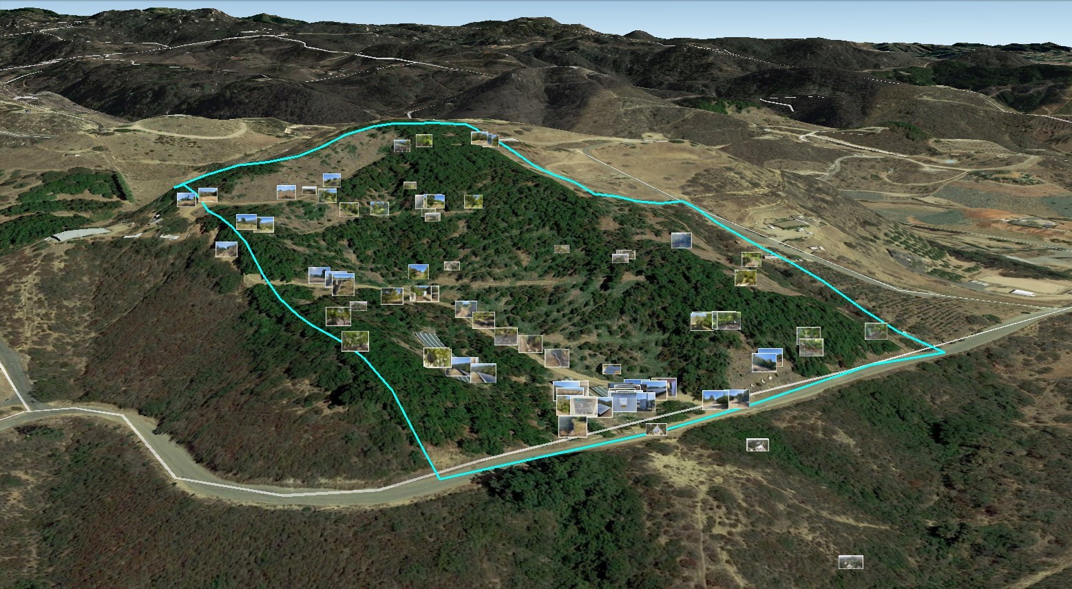
Exhibit 1: Ground and drone images pinned on an orthomosiac layer in Google Earth |
As shown in Exhibit 1, when integrated into software such as Google Earth or ArcGIS, a holistic record of all images recorded on a property can be created. This holistic record can add context for off-site clients and creates a dynamic record of the observed condition of the property. Geotagged images can facilitate virtual property tours and allow for a level of understanding and context that individual photographs simply cannot provide.
Drone Imagery
Over the past decade Unmanned Aerial Vehicles (UAVs), commonly known as drones, have become increasingly commonplace. Manufacturers, such as DJI, have brought to market drones that are portable and powerful. As with the previously discussed ground imagery, drones with integrated GPS capabilities allow for aerial photographs and video imagery that is ideal for pinpointing the location property improvements. Advanced drones can even integrate multi-spectral sensors that aid in identifying irrigation issues and changes in crop growth. Drone imagery can also allow access to areas of properties that would otherwise be difficult to obtain due to road conditions, topography, etc.
Drone photographs can be processed as orthophotos, which are aerial images that have been corrected for perspective and distortion. These orthophotos can be stitched together with software to create a custom, high-resolution, orthomosaics image layer that can be integrated directly into GIS software to illustrate the current condition of a property and can even provide a 3D perspective of newer structural improvements.
Satellite Imagery
While ground and drone imagery provide ideal visual insight into agricultural properties, the agricultural investment world has become global, and physical access to a property may not always be practical or even permitted. The use of mapping and GIS applications, such as Google Earth or ArcGIS, have become commonplace in agricultural real estate and can allow quick access to higher-resolution aerial imagery to easily view property features. These images have been orthographically corrected to allow for estimating the size of both improvements and planted areas. Unfortunately, it is not uncommon for satellite imagery of rural market areas to be outdated.
Launched in 2015 and 2017, the Sentinel-2 satellites provide near-current imagery across the globe. Though the imagery is inferior in resolution to the orthomosaic images creates from low-level UAVs, most regions of the United States have updated imagery available every 2 to 3 days and, with the anticipated launch of a third Sentinel satellite in 2023, imagery is expected to continue improving. The availability of high-frequency historical satellite imagery can allow for a detailed timeline of property changes, such as the development or removal of permanent plantings and larger property improvements. For example, Exhibit 2 shows an almond orchard in California’s San Joaquin Valley. Utilizing the high-frequency Sentinel-2 satellite imagery we can identify the precise dates of key changes in the property’s redevelopment over the past two years.
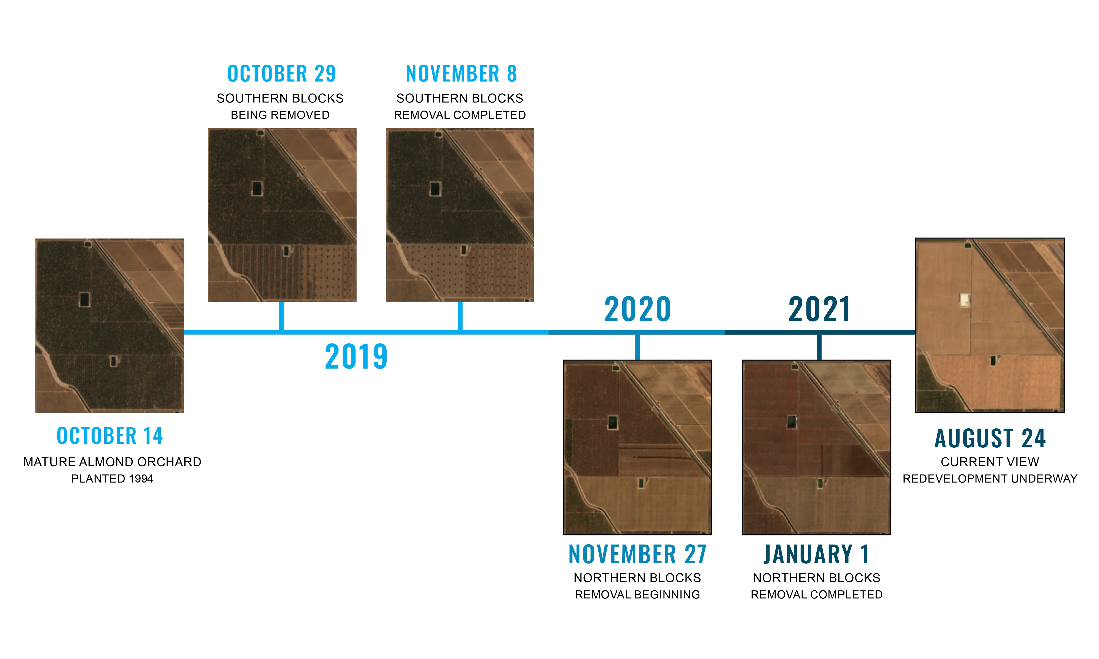
Exhibit 2: The timeline illustrates the redevelopment of a former almond orchard.
Conclusion
Ground and drone imagery can provide visual detail on a property that, by capitalizing on integrated GPS metadata, gives users and clients a holistic view of property improvements, crops conditions, and more. While these images may be limited to the property’s condition as of a specific date, the use of high-frequency satellite imagery, like those from the Sentinel satellites, can provide a unique view of a property’s evolution over time. Whether for agricultural appraisal, management, or investment, leveraging the recent advancements in digital imagery allows for a better understanding of a property’s condition and history leading to superior property analysis.
Jeremy Darner is a Managing Partner for Peoples Company’s Pacific West office. The Pacific West office provides brokerage, appraisal, and consulting services across the major farming areas in the region. For more information on how we utilize geospatial intelligence to better serve our clients please contact Jeremy at jeremy@peoplescompany.com.
Agriculture
Crop Insurance
Energy Management
Industry Insights
Land Auctions
Land Investment Expo
Land Management
Land Values
News & Events
Real Estate
Peoples Company proactively works to anticipate the needs of those in the agricultural sector. Our monthly email publication keeps readers in the know about everything land.
